Maps and Locations
Campus Maps and Directions
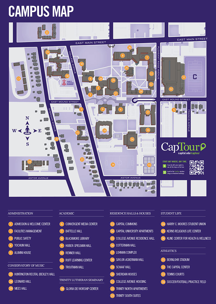
- Map of Capital's main campus, including buildings and parking (PDF)
- Map of Bexley/Columbus area and Capital, including roads and interstates (Courtesy of Google Maps)
- Directions to Capital's Law School (located at 303 E Broad St)
Planning a trip to Capital? Find out about the different kinds of campus visits.
Learn about planning your visit with local hotels, restaurants and shopping.
Visitor Parking on Campus
Visitor parking is located at the Mound Street Plaza just west of Pleasant Ridge Avenue. Use the campus parking map (PDF) to locate the lot. When parking places are not available in the visitor parking lots, visitors may park in any campus lot with a valid visitor permit.
Visitor permits may be obtained at:
Public Safety Office
661 College Ave (corner of College and Mound)
Short-term (15-minute) parking spaces are located behind Yochum hall and next to the Campus Center.
Directions to Capital's main campus in Bexley, Ohio
From Port Columbus International Airport
- Capital is within a short flight of many major U.S. cities. Chicago, Atlanta, Nashville, Washington, D.C., and New York City are all within 90 minutes of Columbus, Ohio. The campus is approximately a 15-minute drive from Port Columbus.
- At the end of the airport's main drive, turn left (south) onto Stelzer Road.
- Follow Stelzer (which will change names and become James Road) approximately 2.5 miles to Main Street.
- Turn right on Main Street.
- Travel approximately 1 mile to Pleasant Ridge Avenue.
- Turn left on Pleasant Ridge Avenue.
From the Northwest
- Travel south on I-75 to Route 23.
- Follow Route 23 into Columbus and take I-270 east to I-71 South
- Travel south on I-71 to the Broad Street exit.
- Turn east (driving away from downtown) onto Broad Street and drive 2.5 miles to Drexel Avenue in Bexley.
- Turn right onto Drexel Avenue and continue south until Drexel ends in front of the campus at Main Street.
- Turn left (east) onto Main Street.
- At the next light, Pleasant Ridge Avenue, turn right (south).
From the East
- Travel west on I-70 to the Livingston Avenue exit.
- Turn left (west) on Livingston Avenue.
- Turn right (north) at the first traffic light onto Alum Creek Drive.
- When Alum Creek dead ends in front of the Kroger store, turn right (east) on Main Street.
- At the fourth traffic light, turn right (south) on Pleasant Ridge Avenue.
From the West
- Travel east on I-70 to the Bexley/Main Street exit.
- Exit at Bexley/Main Street. The exit ramp automatically turns onto Alum Creek Drive, which will dead end at Main Street (in front of the Kroger store).
- Turn right (east) on Main Street.
- At the fourth traffic light, turn right (south) on Pleasant Ridge Avenue.
From the North or South
- Travel I-71 to the Broad Street exit.
- Turn east (driving away from downtown) onto Broad Street and drive 2.5 miles to Drexel Avenue in Bexley.
- Turn right onto Drexel Avenue and continue south until Drexel ends in front of the campus at Main Street.
- Turn left (east) onto Main Street.
- At the next light, Pleasant Ridge Avenue, turn right (south).